Introduction
CityScope platform for the web
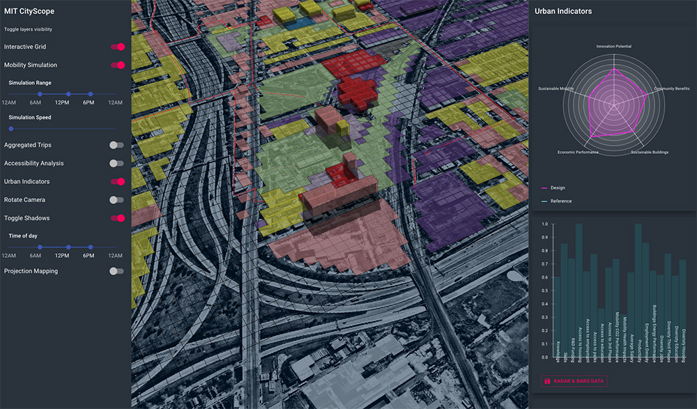
CityScopeJS is the unified front-end for the MIT CityScope project. CityScopeJS allows users to examine different urban-design alternatives and observe their impact through different KPIs and matrices. CityScopeJS brings together different urban analytics modules, such as traffic simulation, ABM, noise, storm-water, access.
What is it for?
CityScopeJS is an online tool with a web interface or tangible user interface (TUI). Using the tool, users can input land uses, buildings, open spaces or transport routes, categorize them and enrich their description with details on usability, density and other parameters. This input forms the basis for calculating the various modules and indicators.
This tool also enables collaboration among people within the City Science Network. By using a single tool for defining projects and visualizations, individuals can easily exchange processes, best practices, and even modules.
CityScopeJS Web interface
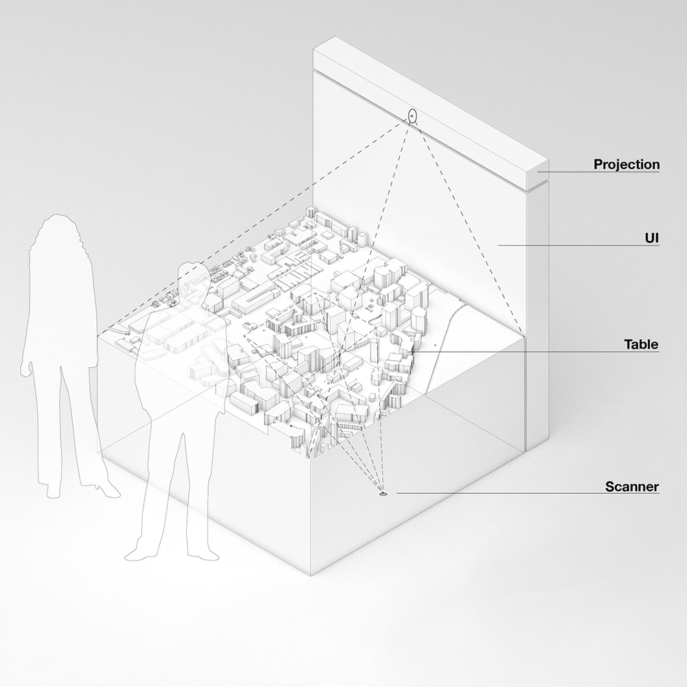
CityScopeJS TUI
CityScopeJS exposes two main features: CityScopeJS Grid Editor and CityScopeJS Palyground
CSjs Playground
CSjs Playground is where users interact with the design of urban areas. The tool is built to allow snappy, real-time intervention with various land-uses. The design is then evaluated using different urban analytics modules.
Quick Start
To explore the app for a known CityScope project, add a CityScope project name to this page URL (for example, __URL__/?cityscope=corktown will run CityScopeJS Corktown project). You can also explore a list of active CityScope projects here.
When in the app, edit the grid using the editing tool, and explore the different analytics updating
Development
CityScopeJS is being constantly developed through its frontend, backend and modules. This repo is subject to breaking changes.
In the project directory, you can run: npm start Runs the app in the development mode.
Open http://localhost:3000 to view it in the browser.
Hard-Reset cityIO GEOGRIDDATA field
Note! This feature involves permanent data loss. If your dev created odd data for the grid, you can quickly reset it via:
`$ curl https://cityio.media.mit.edu/api/table/clear/__TABLE_NAME__/GEOGRIDDATA`
CSjs Grid Editor
The CSjs Grid Editor is a helper tool to bootstrap new CityScope projects. It allow a quick creation of:
- a CityScope endpoint on CityIO
- a geo-located, 3D, editable and contextual CityScope grid
- a list of land-uses to be used during the project
CityScopeJS schema
This document illustrates the data format and standards for the deployment of a CityScopeJS instance. Being a WIP project, this is subject to change.
Data Requirements
geogrid:geojson
Minimal data for initiation is a valid GeoJson FeatureCollection of at least one Polygon feature.
Ideally, this field should be read once on init, due to its size and static state. User should not iterate over it.
{
  "type": "FeatureCollection",
  "properties": {
    "header": {},
    "interactive_mapping": {"1245":{"TUI":"1"},"1472":{"WEB":"1"}}
  },

  "features": [
    {
      "type": "Feature",
      "properties": {},
      "geometry": {
        "type": "Polygon",
        "coordinates": [
          [
            [
             __lat__,
              __long__
            ],
            ...
          ]
        ]
      }
    }...
  ]
}
optional fields
interactive_mapping: maps the grid cells that are interactable via the HCI/TUI CityScope interface or web/mobile UI. This allow mixing of different interactions without overwriting. Format
{
	"__feature_number__": {
		"TUI": "__TUI_CELL_NUMBER__"
	},
	"__feature_number__": {
		"WEB": "__WEB_INTERACTION_CELL_NUMBER__"
	}
}